Monday, November 16, 2015

Magic Wood and Margalef

After spending some quality adventure time on the Long Trail, I moved straight into a few months of getting back to the basics with my training for running.  I noticed at the White River 50 this past July that one thing I was severely lacking, compared to runners who finished just ahead of me, was basic speed.  For quite a while during that race, I was running in a train with two other girls and it was pretty clear that while we were all temporarily going the same pace, that pace was much easier for them than it was for me.  So I took three months to focus on speedwork:  sprints and strides, leg and hip strengthening exercises, and plyometrics.  Word of advice, go easy on the plyometrics if you haven't been doing them regularly--I was nearly broken after my first, and highly overenthusiastic, session!

The three months of speedwork were mostly a success.  I got a new PR in the mile (5:49 in a road race), and I could see that my stride had improved.  But although I truly love going to the track and running short fast repeats, one thing that is missing from a steady diet of speedwork and road racing is variety.  So, it was time for a climbing trip.

I arranged to meet my friend Dave at Magic Wood, in Switzerland, for a few days of bouldering, and then we would drive from Switzerland to Catalunya for about 10 days of sport climbing at Margalef.  I'd never been to Magic Wood before but it only took about an hour at the crag before I was telling Dave that we had to come back soon.  The climbing is just excellent there.  There are a lot of problems with rough landings, which normally isn't my thing because I'm very protective of my ankles, but the amazing rock quality made it completely worth it, plus there were plenty of problems to try that had perfectly good landings.  I surprised myself by getting up a 6C called U Boot, and then had a day to spare to go around trying other problems that looked good.  This was one of them, although the sit start was a lot harder than it looked and will need a return visit!

Photo:  Dave MacLeod
  Dave had even more success there, seeing off his 8B project much earlier than planned and then topping that off with another 8B on the same night.  We also had another type of success:  beautiful weather every day and super scenic running.


After Magic Wood it was time for some Margalef action.  I've got a 7c (5.12d) route there that I've worked on occasionally over the past few years, but this year I had decided it was time to do my best to get it done, and I trained specifically for it for three months before the trip.  I arrived in Margalef knowing that I probably hadn't managed to get trained to anywhere near 7c but that it would still be fun to give the route a try.  The first day was...not promising, to put it mildly.  It was still way too hot for climbing at the crag, my route was far steeper and harder-looking than I remembered it being, and I had forgotten how difficult it can be to block out the noise of the vans, dogs, and climbers at Laboratorio in order to still get some climbing done.  I was so discouraged that I told Dave that I might be making this a running holiday instead of a climbing one...which to be fair is no bad thing since Margalef is also home to my very favorite running trails in the world.

Fortunately, the second day on the route brought a lot of improvement.  It sounds a little ridiculous to talk about improvement when I still couldn't actually do any of the first three moves on the route, but I knew there was now a tiny bit of hope.  Those first three moves are the crux, and there are several possible methods of doing them, so I spent a long time experimenting with different options and finally found one that looked like it was going to work, courtesy of a video that I found online of someone doing the route in a particularly unlikely-looking way.  Unfortunately, by this time, there were only two days left in the trip, and one of them needed to be a rest day.  On the last day, I pulled on and did the crux first try.  I fell off soon after, came down, and had another go--and made it to the last of the hard moves.  I knew my sequence was a bit uncertain here, so I spent a long time trying a section of about ten moves or so, and Dave supplied some key beta that got me a solid chance of getting through that last hard move.  But my arms had nothing left, and my day was over.  Time to go back ASAP...


Friday, August 7, 2015

My Long Trail attempt

It's hard to believe that I was only on the Long Trail for three and a half days. It feels more like three and a half lifetimes.

I was trying for the unsupported record, which is 6 days, 17 hours, and 25 minutes.  It's held by Travis Wildeboer, someone who I know is a very good runner and hiker, so I knew that trying for the record would be a big challenge.  But I was excited, trained, and ready.  I had several last-minute changes of mind about what gear to bring, but both Zpacks and Borah Gear were very helpful about getting me what I needed in just a couple of weeks.  I ended up with a pack of 6 pounds of gear and 8 pounds of food, far heavier than what I'm used to carrying but the minimum I could expect to get away with on something this long.  ("Unsupported" means that you carry all of your gear and food for the entire way with you from the beginning to the end and don't buy anything, or accept trail magic, along the way.)

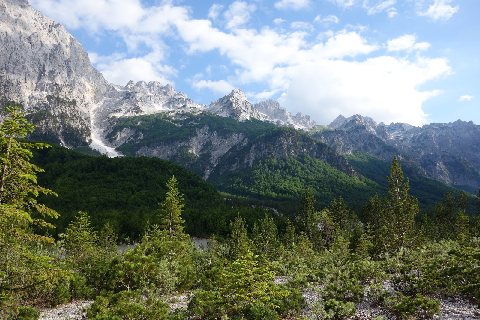
The Long Trail is about 273 miles long but very uneven in terms of difficulty.  Going southbound, as Travis did and as I would be doing, the first 115 miles or so are mostly extremely rough, rugged, and hilly.  Then there are about 30 miles of moderate trail, followed by about 125 miles of much easier trail.  When Travis set his record, he did 30 to 35 miles a day on the harder sections and then 45 to 55 on the easier sections, followed by a 60ish mile final push.  My plan was to end each day in the same place as he did until day 5, then try to gain an extra 5 to 10 miles on his schedule and come in around 6 days and 15 hours.

On Saturday, August 1, I got an early morning ride to the approach trail to the northern terminus.  The thing about the Long Trail is that you can't just get dropped off and start.  First you get dropped off part of the way up a gravel road.  Then you hike up the road to the approach trail.  Then you hike 1.3 miles to the Canadian border, where the Long Trail starts.  In other words, there's a fair bit of extra work that you get no credit for in your first day's mileage!


The first 4 miles of the trail lull you into a false sense of security.  Nothing in those miles was particularly hard; basically just your standard Superior Hiking Trail fare with some slightly bigger hills thrown in.  The calm trail went on for long enough that I almost started to wonder if all the reports of it being so rough were from people who had never been on any technical trails.

Then things changed.  First, the mud from the previous few weeks of serious rain got deeper and deeper:

Standard mud for the first 30 miles

I decided not to step where my trekking pole went in...
Then the more technical ground started coming thick and fast, beginning with a steep, rocky, and narrow climb up Jay Peak.  I was highly disappointed when we didn't get to just walk up the ski hill!  There were some good views when we crossed the ski run, though:


Between the mud and the very technical descents and the steep ups and downs, I was beaten and ready to quit by mile 14.  Mile 14!!  There were still 259 miles to go.  And as I would later discover, I wasn't even at the hard part yet.

At Tillotson Camp, just short of mile 23, I sat down next to the shelter and tried to regroup.  Something was going to have to drastically change in order for me to make it through the day, let alone through the whole trail.  I tried to adjust my expectations for the day from what they had been--to do 30 miles slowly and comfortably and arrive at the end of the day feeling fresh and ready to do more the next day--to what they needed to be, which was to be ready to deal with a higher level of pain than planned and to keep slogging through the miles regardless, for the next 6 days.

It didn't help that just past Tillotson Camp was a beautiful little pond:


The sun had come out, it was a beautiful afternoon, and there were some guys fishing and relaxing by the pond.  They looked to be having the perfect day and I suddenly wanted to relax and enjoy myself too.  Why was I out here working myself so hard?  I couldn't quite answer that but pressed on.  I was rewarded with a lucky break--after the top of the next peak, the trail eased off a bit and the descent to mile 27 was really quite pleasant.  The easier trail continued all the way to mile 30 and the Devil's Gulch:


Devil's Gulch was not what I wanted to deal with at the end of my first day on the trail, but it's only a third of a mile long and passed by quickly.  Then it was just a quick jog from the end of the gulch to Spruce Ledge Camp, my shelter for the night.  I had done 30.5 miles with over 10,200 feet of ascent.  In other words, it was as hilly as the Hardrock course but with much more technical ground and mud--though fortunately no altitude to deal with!

I had a nice stay at the shelter and met some very friendly people, but it was too cold for me to sleep much and I eventually got up and got back on the trail around 3am.  The nighttime was fantastic; there was a bright moon, I was on a fairly easy section of trail, and I was feeling stronger than the day before.  When the sun came up I stopped for a relaxing breakfast on the climb up Butternut Mountain:


In fact nearly all of this day went well.  For one, the forecasted thunderstorms never materialized. And although Laramay Mountain was tough, with all the mud and wet rock, the entire way from mile 40 to mile 55 was largely easy to moderate, and it would have all been runnable had I not still had 6 days' worth of food in my pack.


Then I reached mile 55, and things went wrong quickly.  There are no less than 1400 feet of elevation gain between mile 55 and mile 56 as you go up Whiteface Mountain.  As in, 1400 feet of ascent in one mile.  Then there's the "descent" from Whiteface, which somehow seemed to have more climbing than descending in it.  (As a motto for the trail, I propose "The Long Trail:  Where Even the Downhills Are Uphill.")  It's all technical and steep, too, and the next peak was no better.  After the next peak there's another 5-mile "descent" full of tree roots, ledges, and boulders.


Out of all the miles I did on this trip, I thought miles 55 to 63 were by far the hardest.  It's difficult to explain exactly how hard I was working here; basically I was putting in the effort level you'd use for a road marathon, except I was moving at 1 to 2 miles an hour.  And this section was relentless--I don't think there was anything that wasn't desperately hard in the entire 8 miles.  I arrived at the picnic area at Smuggler's Notch, my end point for the day, in a huge amount of pain and ready to quit this run.  I convinced myself to at least spend the night on the trail and see how I felt in the morning, but I had low hopes for actually continuing on.  The only good part of my situation was that it was the night where I got to stay in the cement outhouse in the picnic area.  It has two toilets in separate cinderblock rooms, so I set up camp in one, locked the door, laughed at my own joke about this putting a new meaning to the phrase "en-suite accommodation," and went straight to sleep.  I couldn't decide whether I found it hilarious or depressing that I was spending my hard-earned vacation time from work sleeping in a toilet block--not to mention that it actually seemed luxurious.

When I woke up everything hurt just as much as it had the night before.  I hadn't set an alarm so it was already around 5:30 a.m. and it was time to either get going or decide that I was done.  I still wanted to quit but made myself pack up all my gear as if I were going to go on, and then once everything was packed, it seemed like I might as well carry on.  Once again I was lucky with the weather; it had been forecast to rain and thunderstorm all morning, which would have been a huge problem since I had to immediately climb up Mt. Mansfield.  Mansfield is Vermont's highest peak and has an exposed rocky summit, definitely not somewhere you'd want to be in a storm.  But somehow I got beautiful sunny weather, and I absolutely loved this part of the trail.


At the visitors' center, I saw my first other person of the day, a woman who was up on the summit to do some type of biology research.  I asked if she could take a picture of me, and as I was walking in front of the rock above for a photo, I stumbled a little and nearly stepped on some grass.  "Except don't step on the vegetation," the woman said to me, sounding as if I had just dropped a bucketful of litter on the ground.  Apparently having legs that were slightly tired from the previous 67 miles was enough to make me an environmental criminal.  At least I got a photo out of the incident, and I'm fairly sure I didn't actually step on the vegetation.

A lot of people had told me that Mt. Mansfield is one of the hardest parts of the trail, which makes sense because it has a lot of scrambling and it's quite a big ascent, but I thought it was one of the easier parts since it was more straightforward--less jumping over tree roots and small boulders and more just powerhiking up a big hill and then (after the scrambling) running down.  After the scrambling and ladder section on the way, down, the trail opened up into some of the easiest trail I had seen so far:


This was a huge morale boost and I made good time for most of the afternoon.  It was hot, there was rain, then it was hot again, and I had to end the day with a super steep section up the Camel's Hump, but I was moving forward steadily.

Climbs up tree roots was a common theme on the Long Trail 

Just before dark I finally arrived, exhausted and dripping with sweat, at the shelter just north of the top of Camel's Hump (mile 92).  I was five miles short of where Travis had stopped on his Day 3, but there had been signs saying that the mile 97 shelter (where Travis stayed) was closed due to bear problems, and I wasn't keen to try to make it all the way to mile 102 without sleep.

My shelter was full of kids from a summer camp, and while there were lots of them, there could have easily been room for me to stay in the shelter as well had everyone moved over a bit.  But when I asked the group leader if they could make some room for me, he replied "No!  We walked a long way today."  A variety of possible responses went through my head but I managed to just say that I had also walked a long way too, then headed off to the back of the shelter to set up my bivy bag on a wooden gear shelf that was at least mostly covered by the back of the roof.  I did however set my alarm to go off at max volume at 5am!  It was cold and uncomfortable trying to sleep on the shelf, though, and I wasn't able to sleep more than a couple of hours.  Hopefully I at least woke up the group leader as I packed my things to start hiking around 2am.

I had a surprisingly enjoyable steep hike up to the summit of the Camel's Hump in the dark, but once on top the weather had changed to a thick, cold fog, and I hurried to get off the scrambling section in case rain was about to start.  I was getting sleepy and made depressingly slow progress on the descent, stopping a couple of times for a quick rest in the middle of the trail.  It was too cold to sleep, though, so I had to continue on at my glacially slow pace.  Finally I got to the next shelter and had a brief snooze on a chair in front of it, waking up when two hikers came through and made me feel guilty for my lack of forward progress.

There were gorgeous views from the top of the next peak:


By about 8am, somewhere around mile 100, I again wanted to quit.  Well, not quit entirely, but quit trying to go fast.  I was ready to give up on the record attempt and "jog it in" which ironically on this trail would involve not doing any jogging at all.  After using every mental trick I could think of, I finally managed to get myself back in the right mindset and moving forward at a pace that was maybe not stellar but good enough to keep me in a position to keep trying for the record.  "It doesn't have to be fast, it just has to be steady," I kept repeating to myself.  I tackled the steep climb up Molly Stark's Balcony more steadily than I thought I would have been able to and was pleased to make it to the top ahead of schedule.  I was so proud of myself for having gotten myself back together and having overcome the desire to quit for at least the fifth time on this run.  And, I had only about 8 more miles before the terrain got significantly easier.

Which is why I was that much more depressed when I got to the top of Molly Stark's Balcony and saw this:


I had survived a few thunderstorms already this trip, but I knew this one was going to be a problem.  For a start, I was at fairly high elevation, and I wasn't going to be coming down from high elevation until tomorrow.  I had to somehow stay warm all night.  I didn't have enough warm clothes to warm up in a high elevation shelter after getting soaked, and I knew I was way too sleepy to be able to stay up all of the coming night.  I had plenty of waterproof gear--waterproof pants, jacket, and mittens--but even they tend to get soaked through in heavy rain.  I get cold quickly at the best of times and in particular now, having not eaten nearly enough food for the past four days and having barely slept, I knew I was about to get very cold.

And sure enough, the storm started, it hailed like crazy, the trail turned into a river of icy cold water, and I froze.


Just as the storm was starting, I realized I had phone reception since I was on top of a hill, and figured it was my big chance to call for a bailout ride if I wanted one.  My mom had been planning to pick me up at the end of the trail, so I called to check if she would be able to come get me now instead.  She said yes.  I hung up and tried to think through my options, feeling more than a bit pressed for time since lightning was now all around me and I was standing on a tall, exposed chunk of rock.  I finally decided it was time to bail.  As the hail built up, the weather turn seemed funny at first, then got scary as I realized it was 1.5 miles of scrambling up and down wet rock, in the middle of a thunderstorm, to get to the road.  The rock was completely flooded with water and the hail kept raining down, getting me scarily cold within minutes.

When I finally made it to the road, I felt like I had made the right decision, since I was so desperately cold that I couldn't imagine carrying on into even higher ground and somehow trying to stay warm the rest of the day and upcoming night.  In hindsight, of course, I keep questioning whether it was the right call.  I could always have walked up to the next shelter and then turned around and gone back to the road if necessary, or I could have cannibalized my sleeping clothes as an extra layer of warmth to make it through the day, then quit the next day if the storm continued.

So after managing to convince myself to keep going through all of the hardest parts of the trail, I somehow managed to quit 8 miles before easier ground.  I'm not too thrilled about how this worked out.  In fact I'd say I'm the most depressed that I've been about a run since Arrowhead 2011.  Part of me is tempted to use the fitness I gained over the past few days to try the trail again ASAP.  Part of me wants to use that fitness for something else, like a mountainous 100 miler or a sneaky late summer Bob Graham Round.  Most of me, though, remembers that the Long Trail was only supposed to be a little adventure during my recovery from the White River 50, something fun that I could as a sort of active recovery before taking a couple of weeks off and then starting training for some fast, short autumn races.  While I can't quite believe I ever thought the Long Trail could fall into the category of active recovery, I still might be better off sticking to the original plan of having a rest period now and getting back to organized training in September.  I'll have to think about it...

Final mileage tally:

Day 1:  30.5 miles
Day 2:  32.8 miles
Day 3:  29 miles
Day 4:  15 miles before bailing at mile 107, Appalachian Gap.  About 3 hours behind Travis at this point.


Thursday, July 9, 2015

Bouldering in Valbonë, Albania

Bouldering near Valbona Pass / Ngjitjes në shkëmbinj në qafa e Valbones

June 2014:  Maria and I hike the long, steep hill out of Okol to Valbona pass in northeastern Albania.  We take in the spectacular views from the top, then start down the other side towards Rragam.  About 10 minutes later, we spot...boulders. Lots of boulders. Perfect limestone boulders with clean rock and flat landings.

July 2014:  Extensive Googling, no sign of established problems on the boulders.  For non-climbers:  this basically means that the hardest routes up the boulders have likely never been climbed.

June 2015:  Divesh and I head back to Valbona pass, this time armed with climbing shoes and a mat...

This post is about our trip in general; more specific information for climbers about the bouldering is here.

We opted to fly into Pristina, Kosovo and make the three-hour drive to Valbona village. There were a few harrowing moments but overall it was an easy drive; there's even a brand-new road replacing the previous semi-driveable dirt road between Bajram Curri and Valbona.  We were a little nervous about how the border crossing guards would react to an Indian citizen, an American citizen, and a rental car, but we had no problems (at least on the way in.  On the way back, we had to stop for a bit while, we assume, they checked the Interpol database...).

Valbona is a village and tourist destination, but it's no hub of services or activity.  Don't expect to be able to buy groceries there, or really anything else from a store. There are, however, several guesthouses and hotels, along with a few restaurants.  Our home for the week was the very nice Hotel Margjeka, about a mile or two up the valley from Valbona.  The view from the hotel is a good introduction to why I couldn't wait to come back to this place:


The hotel was also home to one of the most insanely comfortable beds I've ever slept in.  With the bed plus the large amount of walking we did evey day, I got some of the best sleep I've had in years on this trip.  It normally takes me about 2 hours to fall asleep; in Albania it was 5 minutes max.

From the hotel it's "only" a 5k walk to the boulders. Sadly that 5k involves walking nearly all the way up Valbona pass.  We generally did it in about an hour and a half, though the brutality of the walk-in is tempered by the fact that there are no less than three little cafes on the way up.  Still, each day at the crag started off with a rest under a boulder.

There is no shortage of fantastic scenery on the walk:


This is actually above the crag, at the top of the pass


About a kilometer below the top of the pass, you get to the crag, which basically looks like this:


It was really hard to get an overall shot of the crag just because of the way the boulders were spread out across the hillside, but the photo above shows some of the main boulders.  Divesh is the figure in the middle of the photo, for scale.

And, the bouldering!  Climbers, see here for a mini topo and information about the problems we climbed.  A couple of representative photos of the climbing:


We had four solid days of bouldering (plus one day of walking in to the crag only to get rained out when we were five minutes away...), enough that I felt pretty strong by the end of the trip.  It was exciting having a blank slate of a crag for putting up new routes; I think I've only ever done one new boulder problem before and suddenly here I was, faced with loads of them.  Most of what we did ended up being low-grade stuff, in part because that's what the majority of the problems were, in part because we only had one small mat so falling off from high up wasn't a great option, and in part because it's hard to decide on a new problem, clean it, work on it, and actually top it out in just a few days.  But things worked out pretty much perfectly, as on our last day, Divesh climbed his project and I climbed mine.

This trip was very different from the trip I had with Maria last year--this year, we had a definite schedule, stayed in a hotel the entire time, and basically saw only one small area.  We met fewer new people than last year, and the trip overall was less adventurous.  But this wasn't a bad thing.  We still met a few new people, and I got to practice my Albanian a reasonable amount (though I never did make it to learning the past tense.  The only verb I can say in the past tense is the verb "to be", so "it was" became my all-purpose expression to talk about anything in the past!)  And even better, we got to see a friend who I met last year, Nexhdet, and also meet his friend Islam, aka the Dalai Lama (a very entertaining Dalai Lama):


Nexhdet is a good cook and cooked us a fantastic campfire dinner!  We were generally always hungry after dinners at our hotel, so having a delicious, huge meal cooked for us was a big deal.


We also ran into my 80ish-year-old shepherd friend from last year, who seemed to be living a fantastic life involving taking the sheep up the hill in the morning, and then visiting friends, drinking coffee, and relaxing in the high meadows in the afternoon.

In the middle of the trip, we went on a half-day trip to Gjakove, in Kosovo, with Nexhdet and Islam.  Gjakove was an interesting little city with a great medieval town center, full of well-preserved buildings from the 16th century:

Crazy bridge, but still standing


We had lunch at this very beautiful old restaurant
On our last full day, we went for a run towards Doberdol, on the route that Maria and I took last year on our Peaks of the Balkans run.  It turned out that 21 miles was a bit much after doing that mammoth walk-in to the boulders every day.  We lurched our way back to the car and collapsed into bed extra early that night.  But, the run was enough for Divesh to start some murmurings about how he'd like to come back and do the whole Peaks of the Balkans trail sometime... Return date TBD but definitely in the cards.


Tuesday, July 7, 2015

Boulder problems and topo for Valbona Pass, Albania

Bouldering near Valbona Pass / Ngjitjes në shkëmbinj në qafa e Valbones

This June, my husband Divesh and I went to climb what appear to be previously-unclimbed boulder problems up near Valbona Pass, in Albania.  I had seen the boulders a year earlier during a run and had played around on them in my running shoes enough to know that it was worth coming back with climbing shoes!  For a start, the area is gorgeous:


The crag consists of about 20 to 30 boulders spread out in a meadow, roughly a kilometer below Valbona Pass, on the Valbona side of the pass.  It was difficult to take a photo of the crag as a whole because the boulders are fairly spread out, but this is one of the main sections of the crag, with Divesh in the center of the photo for scale:


What the climbing's like:

The rock is limestone, which makes the crag interesting because you don't often get free-standing limestone boulders.  The boulders all tended to have a couple of slabby sides with easy to very easy problems, and then an overhanging side with (much) harder problems.

For the most part, the rock quality is extremely good, especially considering the boulders were unclimbed and are at the top of a mountain pass.  The slabs and vertical problems needed very little, if any, cleaning.  On slabs, the rock was generally 100% solid.  Vertical problems generally had one or two snappy holds on them.  The overhanging problems tended to have several loose and/or dirty holds that needed cleaning before climbing.  In comparison to most unclimbed rock, however, the amount of cleaning even on the overhanging problems was minimal.

There are two downsides to the crag, though.  First, the boulders tend to be either very lowball or very highball.  There was enough in between to keep us busy for a week, but we would have started to run low on options after that.  Because of airline luggage fees, we only had one small mat with us, which made the highballs unappealing; if we had had more/bigger mats, we probably would have had another week's worth of climbing to try.

The second downside is the grade spread.  We found absolutely loads of easy problems, in the Font 4 to Font 5+ range.  Don't get me wrong, those easy problems were almost all fantastic climbing, but they also weren't projects to work on.  After the easy problems, there were relatively few moderate problems, and then there was a fair bit of scope for very hard (7C and up?) problems.  Again, there were just enough moderates to keep us going for a week, but after that it would have become slim pickings.  (For reference, I climb 6C at my best and Divesh climbs 7A+)

I made a *very* rudimentary topo of the crag using an aerial shot from Google Earth:


This was the max that Google Maps would let me zoom in, so there are several boulders that we climbed on that are missing from the topo.  But, the 8 boulders on the topo are the primary ones we established problems on.

We didn't do any earth-shattering climbs that would demand a detailed description.  This is a general idea of what we climbed:

1.  Kuzhinier boulder:

A.  On the face directly in front of you as you come up the path from Valbona, a Font 5+ going up the bulge on the righthand side of the boulder, about 3 feet from the arete.  The crux is the first two moves, then excellent climbing to the top, with a slightly worrying topout onto a slab.  See photo:


B.  Another Font 5+ going up the twin cracks on the arete, just to the right of problem A.

The downclimb for the Kuzhinier boulder is on the west corner of the boulder, past a small hole.

There is scope for an enormous amount of new problems on this boulder, including easy, moderate, and hard problems!


2.  Franxhollë boulder:

We didn't climb any problems on this boulder because it got a bit high for our little mat, but I've marked it on the topo as it looked like it should have some good moderates on the north and west sides.


3.  Unnamed boulder just south of the Franxhollë boulder:

A.  On the northeast arete, an excellent Font 5 jug haul going up the scoop in the arete, traversing slightly right along the break:


B.  About ten feet to the right of problem A, a 6A to 6A+ mantle problem, also very nice climbing.


4.  Shqip boulder:

This boulder is a minute or two across the hillside (south) of the other boulders.

A.  Shqip Prow, 6C.  Rising traverse up the prow, from the prow's left side as you're facing it, and top out at highest point of prow:


B.  Font 5 up the groove to the right of Shqip Prow:


There would be a nice moderate problem up and over the right side of the prow.


5.  Triangle boulder:

When looking downhill (east) from the Franxhollë boulder, you'll see an obvious boulder with a huge triangle-shaped sloping hold.  The boulder is fairly short but the Font 4+ problem going straight up from the triangle (not using the other triangle hold on the arete or any of the other holds on the arete) is my favorite problem of the whole crag:


(I'm actually covering up the triangle hold in the photo)

6.  Secret boulder:

This boulder may be hard to find, but it was worth it.  It stays shaded when the rest of the crag is in the sun, and it had three nice problems, with scope for another quality 6Cish problem.

To find the boulder, look for the very tall boulder with trees growing out of the top (the Tall Trees boulder).  The Secret boulder is immediately downhill from the Tall Trees boulder, almost touching the Tall Trees boulder.  The visible side of the Secret boulder is a large slab, but on the other side is a short overhanging face with three problems:

A.  Font 6A?  Sit start on the left (as you face the overhanging side of the boulder) arete.  Rising traverse to the prow in the middle of the boulder, then top out.

B.  Font 5, directly up the prow.

C.  Font 5+, up the groove to the right of the prow:


The prow is just out of shot on the left side of this photo.  Starting in the groove and traversing the lip left to the prow, on the slopey lip where Divesh's head is in the above photo, would make an excellent problem, 6Cish or maybe a bit harder?


7.  Tall Trees boulder:

The very large boulder with trees growing out of the top.  There are two boulders big enough to have trees growing out of them but this was the bigger of the two.  We didn't climb anything on this, but with enough pads, there would be some nice hard problems here:


8.  The Egg:

The somewhat egg-shaped boulder in the southern of the two scree gullies running through the crag.

A. There are so many possible starting holds that it's difficult to describe the problem that Divesh did (I managed the crux once but without the first move!).  Essentially, the most difficult route up to the small ledge halfway up the boulder.  We jumped down from the ledge; the rock above was loose:


Getting here:

The easiest travel option is to fly into Pristina in Kosovo, then rent a car and drive the approximately 3 hours to Valbona.  Valbona has several places to stay; we stayed in the Hotel Margjeka and it was very nice (not to mention cheap!!).

It is definitely a hike from Valbona to the crag!  It's about 5km but all uphill, and when you're down in the valley, the sun can make the walk-in uncomfortably hot.  Fortunately the temperature difference between the valley and the crag is huge, and it was never very hot at the crag.  I wore my down jacket for a fair bit of the time when I wasn't climbing, and this was in June!

To get to the crag from Valbona, you take the paved road (there is only one paved road...) west out of Valbona.  In about 2 miles, the road ends in front of the Fusha e Gjes hotel.  Park there and follow the path marked with red and white stripes up the scree road.  This is technically a road, though nothing other than a Jeep/heavy duty 4x4 would get up it.  The "road" goes to a small village called Rragam.  Continue to follow the red and white markings and signs for Theth, which is the town on the other side of Valbona Pass.  Rragam has two tiny little outdoor cafes, and I would recommend making use of at least one of them to rest before the big uphill!  When you leave Rragam there are two trails, one going to the waterfall (ujevara), which you don't want to take, and one that is marked with red and white stripes, which you do want to take.  The trail steepens and about 2km later ends up at another small outdoor cafe, the Simoni cafe, which is also a fine place for a rest.  It also has a stream where you can get water.  From the Simoni cafe you continue to follow the red and white striped markings for about half a km, after which you'll emerge in a field of boulders.  The large boulder directly in front of you, with the red and white striped marking on it, is the Kuzhinier boulder.

If you have a GPS, you can follow this description in reverse from the Fusha e Gjes hotel to just before Valbona Pass to find the boulders.

Valbona has restaurants but food is not exactly plentiful.  Restaurants don't necessarily serve even half the food that's on the menu, and a lot of the cuisine revolves around tomatoes, cucumbers, bread, cheese, and milk.  There are no stores in Valbona that sell food, other than bars that sell basic snacks like potato chips and nuts.  Bring crag food with you from home.

In short, considering the fairly involved travel and the long walk-in, this isn't likely to make a good destination crag.  What it is perfect for, however, is a trip that's about seeing a beautiful place as much as it is about climbing.  Or, a trip to snag some of those very hard but very good lines we had no chance at!

View from the top of Valbona Pass