The Bob Graham Round is actually where ultrarunning started for me. About 8 years ago, when I was living in Leeds, running the odd road marathon here and there and doing a lot of climbing, my friend Ali mentioned that there was this challenge in the Lake District called the Bob Graham and that I should try it sometime. It was the first I had ever heard of people running for longer than 26.2 miles. I looked into it a little and never seriously thought about trying it, but in looking into it I found out about all these ultra races that looked so intriguing and just had to try a few. So 8 years later when my friend Nick said he wanted to do the BG and that I should come with, I said I would.
The BG isn't very well known in the US but in the UK it's a popular long distance challenge. The idea is to do a round of 42 peaks in the Lake District, starting and ending in Keswick. Depending on the exact route you take between the peaks it's about 65 or 66 miles. You've got 24 hours for an official finish. It's the terrain and the ascent/descent that makes it hard--27,000 feet of ascent (that's ascent only, not ascent and descent...) and not much of what American runners would think of as "trails": there are grassy paths through boulder fields, boulder fields on their own, scree, etc.
For an official finish you also need witnesses for you getting to each summit, so the support crew logistics are fairly involved. I ended up with a great team of pacers and road crew who all kindly gave up their weekend to come out at antisocial times of day and night to help me. I owe a HUGE thank you to Nick for organizing all the support crew even after he decided he wasn't going to do the run himself. He saved me from what would have been many late nights over the past few weeks.
Leg 1: Keswick to Threlkeld
12.5 miles
5,125 feet of ascent
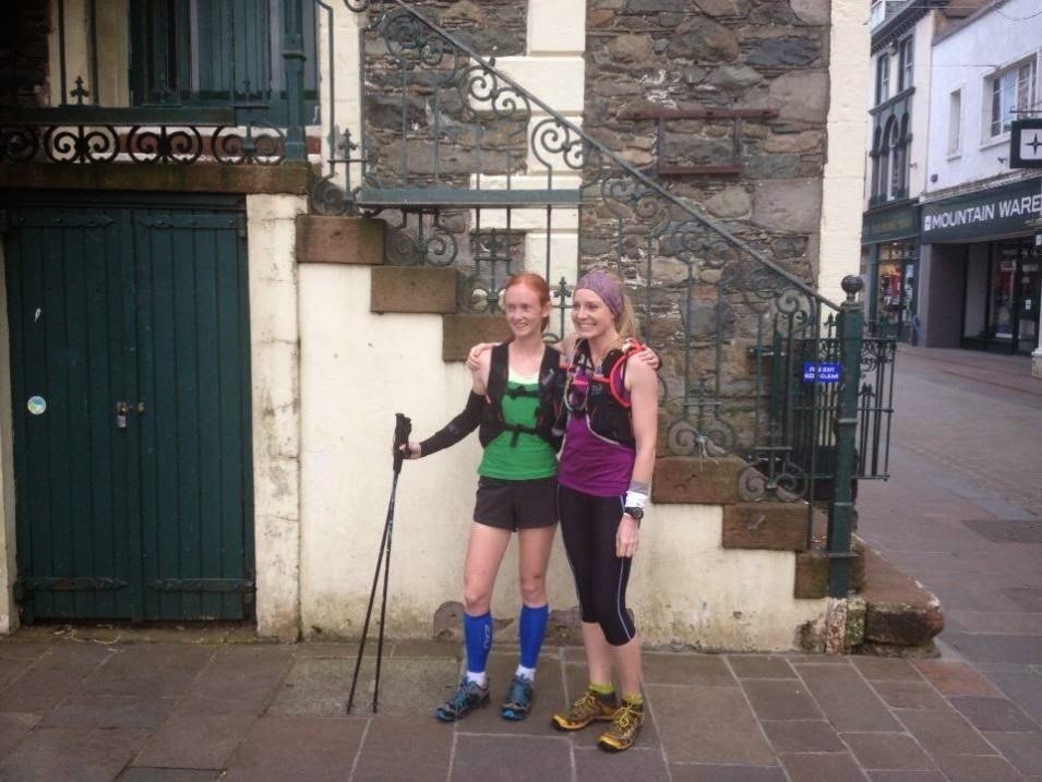 |
| At the Moot Hall door starting line. |
 |
| Jen was so prepared! |
I set off from the Moot Hall at 6:30pm on the dot with Jen Adair, my amazingly generous pacer for this leg. I had only recently met Jen and yet she gave up her birthday weekend to pace! Not only that but she was also great at pacing--she was way organized, super supportive and encouraging, and a great navigator.
After a surreal start next to a bunch of men dressed up in Star Wars costumes (??) we did a slightly overexcited run at 10k speed out of central Keswick and then got back to reality for a nice power walk up Skiddaw. We did arrive at the summit 5 minutes early but after that all calmed down and we stayed pretty much exactly on schedule the rest of the leg. It was a beautiful evening and it felt more like a nice run with a friend than a big hard event. We fought our way through the horrible bog sections in the middle of the leg and arrived at Great Calva and Blencathra on time. I had decided to do the top part of the Blencathra descent on the super steep grass next to the scree field and it was the first, but not the last, time on the round that I looked down and thought "What am I doing?!" I tried to block out the enormous vertical drop below me and ran down as best as I could, traversing over to the Hall's Fell ridge where it got more runnable and then doing my best (which is not very good) to run down that.
 |
| Leg 1, looking back towards Great Calva. Not from the actual attempt but from a recce run we did earlier in the week. |
We got into Threlkeld 15 minutes ahead of schedule, a good time I thought--we had a nice buffer but we hadn't completely overdone it. My amazing road crew, Roslyn and Katusha at this point, had a nice cup of tea waiting for me and we did a quick reloading of food and water. Jen's boyfriend Andrew had come out to cheer and he and Katusha both took some videos of us coming in; looking back at them now it seems like a lifetime ago that we looked that fresh!
Leg 2: Threlkeld to Dunmail
13 miles
6,020 feet of ascent
Leg 2 is the "easy" leg of the BG so we had set up my schedule for this to be the night section. We also had the generous help of Clare Holdcroft, who I didn't know but who had responded to Nick's request on a running forum for more pacers. Having her there was really helpful because she could provide a nice morale boost and help carry my food, which left Nick, who was also pacing this section, to do the navigation--which he did very well; we stayed right on course all night.
Other than getting to see the moon on the climb up Clough Head, I didn't particularly enjoy this leg. I was feeling nauseated most of the time and I never like running at night. We lost a few minutes of time as well, and on the final descent I managed to step into a ravine and twist both feet, a painful jolt at 3 a.m...
Leg 3: Dunmail to Wasdale
15 miles
6,640 feet of ascent
I kept my stop with the road crew at the end of Leg 2 to a minimum in order to make up the time we had lost on that leg, which was hard to do because all I really wanted to do was spend time with the great people in my support crew! But all too soon it was time to set off on Leg 3. Leg 3 is the hardest leg of the route. It's the longest, it comes right in the middle after a tiring night, and the last half of the leg really packs in the hard climbs, with mostly rocky ascents and descents and an actual scramble to get up Scafell.
 |
| Bowfell (also not from the actual attempt; thanks for the photo, Nick) |
 |
| Lord's Rake (not from the actual attempt either) |
Nick pushed through some pain to carry on pacing me for most of this leg. I also had the secret weapon of Andy Hobson pacing me, and that completely turned my day around. He had gone to check out the route just for his pacing job, he was great company, and he was able to keep me going through some pretty rough patches. I had been nauseated ever since the end of leg 1 and it was getting worse by the middle of leg 3. Eventually, in the middle of a particularly hard climb, I stopped to throw up and then decided to spend 10 minutes or so resting to see if I could reset my stomach. I hadn't been eating much, I was starting to slow down and get behind 24 hour pace, and I knew I was going to need some food in order to be able to make up time later. I figured that even though we didn't have any time to spare, it might be a good investment to spend some time on a rest if that would get me eating again. And after my experience at Cruel Jewel only 3 weeks ago, I wasn't keen on spending the whole race being sick--I wasn't even sure I would have wanted to continue if I were to stay that sick.
Surprisingly enough the stop worked. After about 10 minutes I ate part of a sandwich and it actually tasted good and was clearly going to stay down. I gave Andy one very relieved look and we started on up the rest of the climb (Bowfell I think? I can't remember). It was a big turnaround point. Andy commented how I had perked right up and it really was pretty exciting to suddenly feel good again and to not have my stomach hurt. It was also a gorgeous morning and I was finally able to enjoy the amazing views we were getting. I started to think that maybe I could actually finish this thing.
We ticked off some of the hardest summits of the leg at a respectable pace but the weather was turning--the wind was so strong on a couple of the summits that we had to crawl at the top! I found the descent off Scafell quite painful and broke part of a toenail off here. In theory that shouldn't have been a big deal but it was strangely painful and ended up bothering me the rest of the run.
Right at the end of the leg we got one of the best parts of the whole day: the good scree gully just above Wasdale. I'm no fan of scree descents but this was the most amazing scree ever, just the right size bits for a soft run/"ski" down. Andy and I were both grinning from ear to ear at the bottom.
Leg 4: Wasdale to Honister
10.2 miles
4,845 feet of ascent
At the crew stop at Wasdale I was met with many more people who I couldn't wait to see. James Rowe had taken over driving duties, and Julie Mair was there to cheer me on and collect Andy. I had two fresh pacers waiting for me: Jen, who had done Leg 1 with me, and Carrie Craig, who was down from Edinburgh to help out. I had had a really nice time running with her for part of the West Highland Way Race and I was looking forward to getting to run with her again.
Leg 4 is my favorite; it has some of the best views and a few big climbs (I'm comparatively faster at the ascents so I do better time-wise on them). It was raining when we set off but only lightly, and the sky was still bright so it didn't seem likely that we'd get the apocalyptic rain that had originally been forecast.
 |
Views on Leg 4, again not from the actual round; far too sunny in the photo for that!
|
Jen and Carrie took great care of me on this leg, holding onto my food, water, and spare clothes and helping me out with whatever I needed. We made good time on the first half of the leg, consistently getting to the summits ahead of schedule. I got another glimmer of hope for making it around under 24 hours. Then...the weather turned. We had just gotten up Kirkfell and a storm rolled in with strong winds, driving rain, and enough mist that we couldn't see anything. We got lost for a while and spent a while wandering around trying to get our bearings and get back on the route. I had just put my waterproof jacket on but I was already freezing and with not a lot of food in my system I was getting seriously chilled. By the time we got back on course I was a wreck. I put on my second jacket plus one of Jen's but just couldn't get warm, no matter how fast we went on the ascents. I spent the rest of the leg in a state of vague panic, not able to say much of anything (Jen told me later they couldn't understand much of what I was saying anyway when I did try to talk) and losing minutes off the pace at a rapid rate.
 |
| Great Gable, from a recce run two weeks ago. Conditions at least somewhat similar to the actual day... |
When we got close to the end of the leg Jen used her demon descender skills to go ahead and tell the support crew what was going on. When I finally got down to Honister they had all my spare clothes ready for me and I did as quick of a clothes change (I had my friend Claire's "adventure trews" as waterproof trousers waiting for me, fortunately, or else I might not have gone out again!) as I could, stood under the hair dryers in the bathroom for a bit (Honister is the best road crew support point because there's a cafe there where you can go indoors), drank a cup of hot chocolate, and headed out again.
Leg 5: Honister to Keswick (or not quite to Keswick, in my case...)
10.5 miles
2,326 feet of ascent
For this leg I had yet more good support. I was rejoined by Andy, plus Nick's friend Katie Reece came out and it was good to see her. I did feel bad for not giving her much of a run though, with my slow pace! In theory this is the easy leg, since it's only 3 summits, 1 big descent, and then 4 road miles back to Keswick. But with the rough end to Leg 4 and the time spent changing clothes and thawing out, I only had 2:15 for the leg, and I knew when I set off that that was unlikely to happen. I gave it my best shot but when we made it to the summit of the last peak at about 23 hours and 30 minutes, it was sadly clearly over. We eased off the pace and did the long, horrible descent back to the road, then Katie ran to get the support crew to pick us up. I had debated in my mind whether I wanted to run into the finish anyway despite missing the cutoff but decided against it since 4 miles on the road in my water-flattened, thin trail shoes would have been pretty brutal on my body. I'd rather just do it again some time and get it right.
It was a hard day. The BG is probably the physically hardest thing I've ever tried. Mentally it's not as bad as something like Arrowhead because you're constantly surrounded by pacers and you get to meet your crew several times, but the unrelenting pace needed for a 24 hour finish at the BG is brutal to keep up for that length of time over that terrain. I also got far colder in the BG than I ever got in Arrowhead!
It was not the outcome I expected--I thought I would either fail sometime during leg 3 or make it to the end--but it was a good experience. It was, after all, 24 hours of running with friends in the Lakes; that can never be too bad of a day.


